
Summary
- ISLAMABAD: Pakistan’s urban landscape has undergone a dramatic transformation over the past 14 years, with satellite imagery revealing expanding cities, merging urban centres and an increasingly visible gap between population growth and urban governance.
- The Lahore urban belt grew from 1,794 to 2,696 square kilometres, while Karachi’s footprint increased from 1,119 to 1,605 square kilometres.
- The difference between the 27 per cent increase in illuminated land and approximately 60 per cent urban population growth suggests that Pakistan is experiencing both outward expansion and greater population concentration within existing urban areas.
ISLAMABAD: Pakistan’s urban landscape has undergone a dramatic transformation over the past 14 years, with satellite imagery revealing expanding cities, merging urban centres and an increasingly visible gap between population growth and urban governance.
An analysis of NASA’s Black Marble night-time satellite data conducted for Minute Mirror shows that Pakistan’s illuminated built-up area increased from 13,259 square kilometres in 2012 to 16,876 square kilometres in September-October 2026, representing a 27 per cent rise. During the same period, the country’s urban population reportedly increased by approximately 60 per cent.
The findings suggest that urban expansion has moved beyond traditional city boundaries, creating interconnected metropolitan regions that existing administrative structures have struggled to accommodate.
Lahore Region Emerges as Pakistan’s Largest Urban Belt
One of the most significant developments is the merging of Lahore, Gujranwala and Kasur into a continuous urban zone, extending towards Sheikhupura, Muridke and Kamoke.
According to the satellite analysis, this interconnected belt now covers approximately 2,696 square kilometres of illuminated land, surpassing Karachi’s estimated 1,605-square-kilometre footprint.
Urban experts describe the development as Pakistan’s emerging megacity region, formed largely through unplanned expansion along the Grand Trunk Road rather than coordinated metropolitan planning.
Sialkot and Daska have similarly developed into a connected urban area, while Islamabad and Rawalpindi have expanded towards Wah and Taxila. Faisalabad has also experienced substantial outward growth.
Uneven Expansion Across Major Cities
The satellite findings indicate considerable differences in urban growth across Pakistan.
Faisalabad recorded a 2.1-fold increase in illuminated area, expanding from 403 to 853 square kilometres. Sialkot also grew by approximately 2.1 times, reaching 330 square kilometres from 154.
Multan doubled its illuminated footprint from 277 to 550 square kilometres, while Islamabad-Rawalpindi expanded 1.8 times, reaching 1,498 square kilometres.
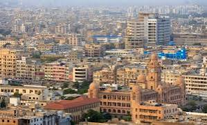
The Lahore urban belt grew from 1,794 to 2,696 square kilometres, while Karachi’s footprint increased from 1,119 to 1,605 square kilometres.
Other cities also registered expansion, including Quetta, Hyderabad and Bahawalpur. Peshawar recorded comparatively slower growth, increasing from 270 to 311 square kilometres.
Population Growth and the Urban Planning Challenge
Experts caution that night-time satellite imagery does not directly measure population. Instead, NASA’s VIIRS sensor identifies illuminated areas associated with electricity consumption, residential settlements, commercial activity and industrial development.
The difference between the 27 per cent increase in illuminated land and approximately 60 per cent urban population growth suggests that Pakistan is experiencing both outward expansion and greater population concentration within existing urban areas.
A Growing Gap in Urban Governance
The findings highlight serious administrative challenges. The Lahore metropolitan belt stretches across four districts without a unified metropolitan government. Karachi’s urban administration remains divided among multiple municipal bodies, cantonments and development authorities.
Punjab’s urban centres have also faced prolonged gaps in elected local leadership, raising questions about accountability and coordinated infrastructure development.
Experts have recommended establishing metropolitan governments, introducing land-value capture mechanisms and incorporating satellite-based night-time illumination into official urban planning.
They argue that property taxes and development-related charges could help finance public transport, sanitation and essential infrastructure
The Way Forward
Pakistan’s cities are expanding faster than their traditional administrative boundaries can accommodate. The satellite images provide a clear indication of how dramatically the country’s urban geography has changed since 2012.
The central challenge is no longer simply managing growing cities but developing governance systems that reflect their actual size, population and economic connections.
Without coordinated metropolitan planning, expanding urban regions risk facing worsening infrastructure shortages, fragmented administration and rising pressure on public services.
We welcome your contributions! Submit your blogs, opinion pieces, press releases, news story pitches, and news features to opinion@minutemirror.com.pk and minutemirrormail@gmail.com