Summary
- UNITED NATIONS: The world may soon look noticeably different in classrooms, textbooks and digital maps after the United Nations General Assembly approved a resolution supporting a more geographically accurate representation of continents.
- The resolution, backed by 164 countries, with one voting against and six abstaining, seeks to encourage the wider use of maps that better reflect the actual size of the world’s continents.
- The UN resolution encourages the use of the Equal Earth projection, which is designed to represent continents and countries in much closer proportion to their actual land areas.
UNITED NATIONS: The world may soon look noticeably different in classrooms, textbooks and digital maps after the United Nations General Assembly approved a resolution supporting a more geographically accurate representation of continents.
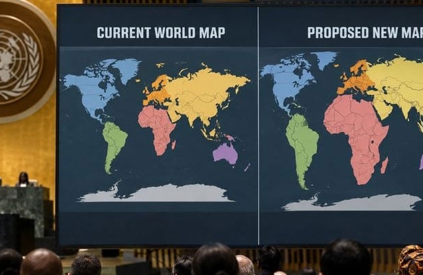
The resolution, backed by 164 countries, with one voting against and six abstaining, seeks to encourage the wider use of maps that better reflect the actual size of the world’s continents. The campaign was led by Togo, alongside African countries and the Bahamas, which argued that Africa has long been visually diminished by the map projection most commonly used around the world.
The debate centres on the Mercator projection, developed in the 16th century by Flemish cartographer Gerardus Mercator. While the projection remains useful for navigation because it preserves directions, it significantly distorts the size of landmasses as they get closer to the poles.
One of the most striking examples is Greenland. On a conventional Mercator map, Greenland can appear roughly comparable in size to Africa. In reality, however, Africa is about 14 times larger than Greenland.
Critics say the distortion has also shaped how generations of students have visually understood the world. They argue that Europe and other regions of the Western world appear disproportionately large, reinforcing outdated perceptions associated with the colonial era.
The UN resolution encourages the use of the Equal Earth projection, which is designed to represent continents and countries in much closer proportion to their actual land areas.
However, the resolution is not legally binding and does not call for the complete abandonment of the Mercator projection. Experts continue to regard Mercator as particularly useful for marine and aviation navigation.
The United States was reportedly the only country to vote against the resolution. Washington argued that the initiative promotes an ideological agenda and distracts from more pressing global issues such as peace, prosperity and international relations.
Togo’s Foreign Minister Robert Dussey, who has championed the campaign, offered a simple message: a fairer world should begin with a fairer map.
France, a co-sponsor of the resolution, has also indicated that it intends to move away from Mercator-style maps in favour of projections that provide a more accurate picture of land area.
Campaign organisers now say the real challenge begins: getting more accurate maps into schools, textbooks, media organisations, businesses and digital platforms worldwide.
Togo plans to update geography materials in its schools by the end of this year and hopes other governments, educational institutions and technology companies will follow.
The message behind the campaign is not that Africa should simply “look bigger”—but that the world should finally see Africa at its true scale.
We welcome your contributions! Submit your blogs, opinion pieces, press releases, news story pitches, and news features to opinion@minutemirror.com.pk and minutemirrormail@gmail.com